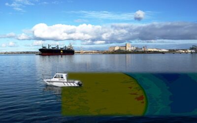
Hydrographic Surveying is the process of mapping the geography of water bodies for performing certain construction works or maritime navigation. Hydrographic Surveyors are the authorized persons who measure water bodies, depending on certain criteria, including water depth, tide measurement, shoreline obstacles, and more.
Applying special equipment, they conduct the measurement task with accurate details. Different techniques are also there for finding the right details, and only the trained and certified professional gets the know-how of water measurement.
The purpose:
It is an important part of the project requiring a change in the area of a water body. Different projects need hydrographic surveys, including:
- Building docks
- Waterway planning
- Removing soils
- Water source diversion
- Wreck location.
Those who are associated with these projects are completely aware of the site layout. So, whenever there is a water-based project, you need hydrographic surveys to measure obstacles in the water and find the right solution.
Job responsibility:
Professionals who perform this task often spend extensive time on vessels, measuring the water obstacles. They stay primarily outdoor, even in adverse weather conditions. Being proficient in both offshore and onshore work, they come up with the project result that helps the construction in the water area go on full swing, avoiding all risk factors. The projects they handle are many international, and they get the regular schedule work.
Water depth estimation:
The term specially mentions the measuring of the depth of water bodies. For maritime navigation, it is the ideal task segment. A professional can handle the task easily and flawlessly. Water bodies contain many obstacles, including irregular soil deposits, coral reefs, and more. These obstacles may cause trouble for a traveling ship. This has become an integral part of port planning and construction. The surveys check the water bodies to determine whether it is perfect for a maximum-sized ship. It is also an essential step for shipping safety.
Accurate planning for your project:
Hydrographic surveying is also required before and after a project to ensure the perfect result. For a river dredging project, a team of surveys examines the area and comes up with the right details of the river bed. After the river dredging, the survey team visits the site to get the result of their work.
Equipment:
Sonar is the primary resource for finding the water depth. It uses sound waves to measure the distance when the sound wave reflects. The sonar method also includes two different systems – single-beam sonar and multi-beam sonar. Single beam helps surveys get the measurement of a single spot, while multi-beam sonar is used for a large area.
Educational qualification needed for becoming a surveyor:
The eligibility criteria for this profession are a high school diploma with industry-specific experience. Higher learning is required to achieve a higher post in water mapping, such as a bachelor’s degree in GIS or geomatics.
Conclusion:
Hydrographic Surveyors are needed for water-based projects or constructions, such as maritime navigation or port planning. They are trained to measure different obstacles lying in the water to find the best solution for carrying out construction.


